Tukino
雪場資訊Field info

- 地區Region
- 北島North Island · 魯阿佩胡山(Ruapehu)東側Mt Ruapehu (east side)
- 類型Type
- 俱樂部雪場Club field
- 最近城鎮Nearest town
- Waiouru / Tūrangi
- 標高/落差Elevation / vertical
- 落差 340m・170 公頃;初級 35%、中級 30%、高級 35%Vertical 340 m · 170 ha; beginner 35%, intermediate 30%, advanced 35%來源source
- 纜車Lifts
- 3 條 Nutcracker 拖繩:Whangaehu Beginner(1,750m)、Aorangi Advanced(1,850m)、Banana Gully(1,970m)3 nutcracker rope tows: Whangaehu Beginner (1,750 m), Aorangi Advanced (1,850 m), Banana Gully (1,970 m)來源source
- 交通Access
- Desert Road(SH1)上轉入,Tūrangi 以南 46 km/Waiouru 以北 22 km;碎石路 7 km 到 2WD 停車場,之後 7 km 只限 4WDTurn off the Desert Road (SH1), 46 km south of Tūrangi / 22 km north of Waiouru; 7 km of gravel to the 2WD car park, then 7 km 4WD only來源source
- 現況Status
- 2025 年起改由志工營運;2026 季已結束,下季 2027Run by volunteers since 2025; the 2026 season has ended, next season 2027來源source
- 3D 地形估算3D terrain estimate
- 纜車約 1,687–1,974 m(落差約 287 m,非官方,依地形資料量測)Lifts about 1,687–1,974 m (vertical about 287 m; unofficial, measured from terrain data)
票價(紐幣 NZD)Prices (NZD)
官網票價Official price 2026 日票:非會員成人 NZ$90、會員 $60;Nutcracker 腰帶免費2026 day pass: non-member adult NZ$90, member $60; nutcracker belt free 來源source
雪道圖Trail map
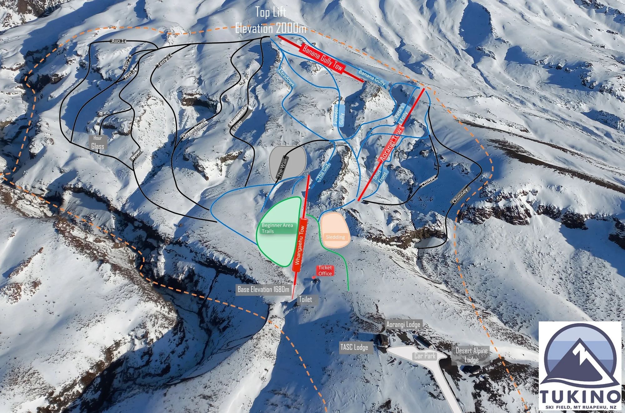 點圖看大圖Tap to enlarge
圖片來源:Tukino 官方網站(Tukino Trail Map 2023)Image: Tukino official website (Tukino Trail Map 2023) · 原始頁面original page。著作權屬各雪場,本站僅縮小轉載供參考。. Copyright belongs to the field; shown reduced for reference only.
3D 雪場地圖3D map
全螢幕Full screen3D 地圖為英文介面。拖曳旋轉、滾輪或雙指捏合縮放;右鍵拖曳、Shift+拖曳、方向鍵、雙指拖曳或右下方向按鈕可平移,「Reset」回到初始視角。名稱預設隱藏,點左上角 ▸ 展開選單後按「Show names」。3D 圖為非官方,纜車與滑道取自 OpenStreetMap。Drag to rotate, scroll or pinch to zoom; right-drag, Shift+drag, arrow keys, two-finger drag or the arrow pad (bottom right) to pan; Reset returns to the starting view. Names are hidden by default: tap ▸ at the top left, then Show names. Unofficial map; lifts and runs from OpenStreetMap.